Centrally Protected Monuments, Raipur Circle
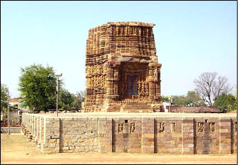
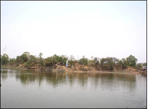
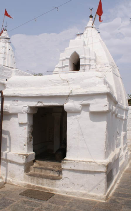
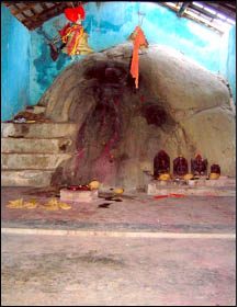
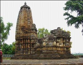
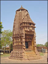
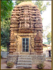
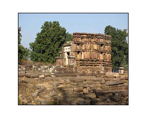
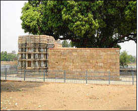
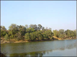
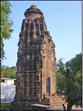
Ruined Shiv Temple, Adbhar District :Janjgir-Champa Place : Adbhar, Shakti
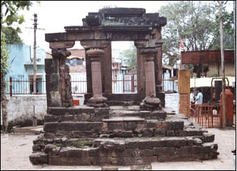
Geo-coordinates: Lat. 210
57’ 11”N, Long.
830 01’ 29”E
The
ruined temple at Adbhar locally known as Devi temple was dedicated to Shiv. The temple comprised of a sanctum, antarala, a mandapa and a detached Nandi-mandapa. The ground plan of the temple is stellate (star-shaped). At present remnants
of the Nandi-mandapa and the highly decorated doorway of the garbhagriha are
preserved. The door-jambs are adorned with large figures of Ganga and Yamuna on
either side at the base. Depiction of Shiv-Parvati , Karttikeya and maladharis are found on the lintel. The
temple is datable to c A.D. 700.
17.04.1913. Declared protected monument vide GOCP, PWD, B&R Branch, Nagpur Notification No.60 dated 17.04.1913, confirmed vide Notification No.C-72-A-B-358 dated 11.04.1925.
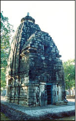
Shiv Temple District :Bilaspur Place : Belpan, Takhatpur
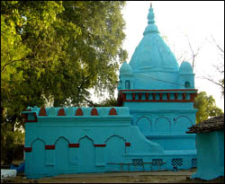
Geo-coordinates: Lat.
220 10’ 41”N ,
Long. 81051’43” E
The east facing brick temple built on a
raised platform is enshrining a shivlinga in its garbhagriha. The entrance door to the garbhagriha is adorned with
floral designs. The temple is datable to
16th century AD
17.12.1920. Declared protected monument vide GOCP, PWD, B&R Branch, Nagpur Notification No. 543Y dated 17.12.1920, which was confirmed vide Notification No.1219-D.A.B dated 26.10.1922.
Fort, Chaiturgarh District :Korba Place : Lapha, Pali
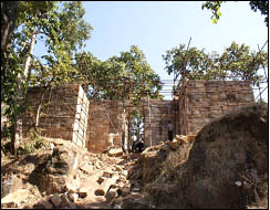
Geo-coordinates: Lat. 220 30’ 37”N, Long. 82016’17” E
Chaithurgarh
popularly known as Lapha Garh is one of the strongest natural fort located at a
height of 3600 ft from MSL in Korba district. Following the geographical features of the hill the fort walls are very
irregular in shape. The fort has three entrances
locally named as Jhandi or Dinda gate , Manka
Dai gate and Hukra gate adorned with different shaped pillars and images
carved beautifully.
A temple dedicated to goddess Mahishasurmardini is situated within
the fort on the hill top. This east facing edifice built of
sand stone on a high platform can be approached through a flight of steps. The
temple comprises of a garbhagriha
with a curvilinear sikhara and a
pillared mandapa. The temple is pancharatha on plan with interiorly square sanctum which houses
an image of twelve armed Mahishasurmardini
where as an image of Ganesha is carved on the Lalatabimba.
17.12.1920. Declared protected monument vide GOCP, PWD, B&R Branch, Nagpur Notification No. 543Y dated 17.12.1920, which was confirmed vide Notification No.1219-D.A.B dated 26.10.1922.
Mahadev Temple, Gatora District :Bilaspur Place : Masturi
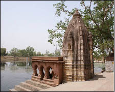
Geo-coordinates: Lat. 220
04’ 08”N , Long.
820 15’29” E
The temple
located on the bank of a tank consists of a garbhagriha
with rekha sikhara and a mandapa. It is saptaratha on plan and the exterior wall surfaces are plain. The temple is dated to 14th -15th
century A.D.
17.12.1920. Declared protected monument vide GOCP, PWD, B&R Branch, Nagpur Notification No. 543Y dated 17.12.1920, which was confirmed vide Notification No.1219-D.A.B dated 26.10.1922.
Chandraditya Temple District :Barsoor, Dantewada Place : Barsoor
Geo-coordinates:
Lat. 190 08’14” N, Long. 81022’58”
E
The
temple built on a high platform dedicated to lord Shiv is believed to have been
built by a feudatory chief (Mahamandalesvara) Chandraditya hence called Chandraditya temple. The temple is pancharatha on plan and consists of a garbhagriha and a pillared mandapa
datable to 11th century A.D.
Date
of declaration of protected area/monument and Notification No. 02.01.1954.
Declared National importance vide Section-02 of the Ancient and Historical Monuments and
Archaeological Sites and Remains (Declaration of National
Importance) Amended Act 1953 (No.3 of 1954).
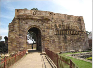
Large Vashnava temple District :Janjgir-Champa Place : Janjgir
Geo-coordinates: Lat. 220 00’21” N, Long. 82034’20” E
This
east facing edifice locally known as Nakata Mandir is dedicated to lord Vishnu.
The temple built of sand stone on a high platform is surviving with a garbhagriha having the remnant of a
Nagara sikhara. The exquisitely
carved door entrance to the garbhagriha
is adorned with images of various hindu gods accompanied by dwarapalas. Among the notable sculptures depicted on the
exterior wall surfaces are Varaha, Narasimha, Brahma, Surya, scenes from
Krishna’s life and from the Ramayana etc.. Stylistically, the temple is datable
to c 11th century A.D.
Date of declaration of protected
area/monument and Notification No. 28.09.1908.
Declared protected monument vide
GOCP, PWD, B&R
Branch, Nagpur Notification No.61
dated 28.09.1908 which is an addendum to Notification No.110 dated 17.11.1906,
confirmed vide Notification No.C- 72-A-B-358 dated 11.04.1925.
Mud Fort, Kashigarh District :Janjgir-Champa Place : Bawanbadi, Jaijaipur
Geo-coordinates:
Lat. 210 51’09” N ,
Long. 820 47’ 05” E
The fort is surviving with a moat and
high rampart wall
Date of declaration of protected area/monument
and Notification No. 17.12.1920. Declared protected monument vide GOCP,
PWD, B&R Branch,
Nagpur Notification No. 543Y dated 17.12.1920, which was confirmed vide
Notification No.1219-D.A.B dated 26.10.1922
Brick Temple of Savari, Kharod District :Janjgir-Champa Place : Pamgarh
Geo-coordinates: Lat.
210 44’26”N ,
Long. 82034’40” E
The
temple, built of brick was originally a Vaishnava temple but later on dedicated
to goddess Mahishasuramardini, locally called Savaridevi. It is panch-ratha on plan with a square
sanctum , vestibule and a later added
pillared mandapa. The original temple can be assigned to circa A.D. 650
during the time of Panduvamsi rule while the mandapa appears to have been added
by Ratnadeva III of the Haihaya dynasty in
1181-82 AD.
Date of declaration of protected area/monument
and Notification No. 10.07.1916. Declared protected monument vide GOCP,
PWD, B&R Branch,
Nagpur Notification No. 180
dated 10.07.1916 confirmed vide
Notification No.G.B-932 dated 27.08.1917 and Notification No.C-72-A-B-358 dated
11.04.1925.
Mud Fort, Kotmi District :Akaltara, Janjgir - Champa Place : Kotmi Sonar
Geo-coordinates:
Lat. 220 01’ 43”N,
Long. 820 20’33” E
The fort with its eastern rampart raising to
about 12 m height is surrounded by a moat on all sides having two gates on the
east and the west sides besides a small opening at the south east corner. It is
believed to have been built in the early medieval period. The fort is dated to
10th -11th century A.D.
Date of declaration of protected area/monument
and Notification No. 17.12.1920. Declared protected monument vide GOCP,
PWD, B&R Branch,
Nagpur Notification No. 543Y dated 17.12.1920, which was confirmed vide
Notification No.1219-D.A.B dated 26.10.1922.
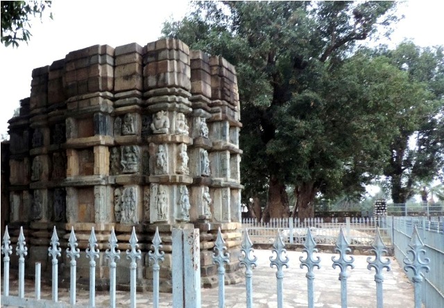
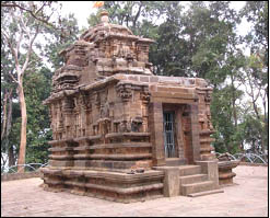
Bhima Kichak Temple District :Bilaspur Place : Malhar, Masturi
Geo-coordinates:
Lat. 210 53’ 35’’ N;
Long. 820 16’ 40’’E
The
Bhima-kichak temple massive in character was dedicated to lord Shiv. At
present remnants of only lower half of the temple is surviving. The entrance
part of the temple is adorned with beautifully carved scenes such as the
marriage of shiv and parvati, the scene depicting the amusement of ganas in the
said occasion, life size images of Ganga and Yamuna etc. The temple can be
dated to C. 6th-7th century AD.
Date
of declaration of protected area/monument and Notification No. 22.07.1937. Declared protected monument vide
GOI, Department of Education, Health and Lands,
Notification No.F.11-8/37-F dated 22.07.1937 confirmed vide Notification No.F.11-8/37-F dated
07.10.1937.
Kanthi Deul, Ratanpur District :Bilaspur Place : Kota
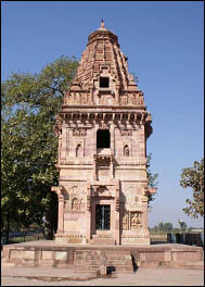
Geo-coordinates: Lat. 220 17’ 21” N, Long. 820 09’ 36”E
This
three-storied temple dedicated to lord Shiv, is unusually tall and unique in
shape and displays fine blending of Hindu and Islamic architectural features. The ground storey is almost plain with a door
opening on all the four sides where as first storey is relieved with projecting
jharokha in the middle besides niches and alcoves on all sides. The structure
is surmounted with a curvilinear sikhara.
Date of declaration of protected area/monument
and Notification No. 28.07.1916. Declared protected monument vide GOCP,
PWD, B&R Branch,
Nagpur Notification No.280 dated 28.07.1916
confirmed vide Notification No.G.B-935 dated 27.08.1917 and Notification
No.C-72-A-B-358 dated 11.04.1925.
Pali Inscription, Semarsal District :Bilaspur Place : Lormi
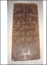
Geo-coordinates:
Lat. 22010’ 01” N ,
Long. 81047’ 24” E
The
Pali inscription on a slab of jasper is engraved in Brahmi characters and
Prakrit language. It records the permanent endowment and excavation of a tank
at Visagama. Two words namely Bhattaraka and Visagama can still be made out in
the inscription which is datable to 1st – 2nd century
A.D.
Date of declaration of protected area/monument
and Notification No. 18.01.1919. Declared protected monument vide GOCP,
PWD, B&R Branch,
Nagpur Notification No.99 dated 18.01.1919 confirmed vide Notification
No.99-F/G-B dated 25.06.1919 and Notification No.C-72-A-B-358 dated 11.04.1925.
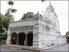
Sheorinarayan Temple Together With Ruined Temple In The Same Compound And The Inscription In Chandrachud Mahadev Temple, Sheorinarayan District :Janjgir- Champa Place : Pamgarh
Geo-coordinates:
Lat. 210 43’ 10” N,
Long. 820 35’22” E
Sheorinarayan
is located at the confluence of three river Mahanadi, Shivnath and jonk.
According to local tradition the place has been named after Shabri, a tribal
woman who had served fruits to lord Rama during his exile as described in the
epic Ramayana. The Chandrachud temple constructed in the first half of the 12th
cent. A.D. is dedicated to Shiv.
Date of declaration of protected area/monument
and Notification No. 17.04.1913. Declared protected monument vide GOCP,
PWD, B&R Branch,
Nagpur Notification No.60 dated 17.04.1913 confirmed vide Notification No.C-72-A-B-358
dated 11.04.1925 and corrigendum
No.22 dated 13.03.1916.
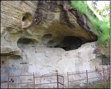
Jogimara Cave District :Sarguja Place : Udaypur
Geo-coordinates:
Lat. 220 53’ 54” N ,
Long. 820 55’ 46” E
The
Jogimara cave facing north-east, lies adjacent to the Sitabengra cave to its
west. The ceiling bears paintings and an inscription in Brahmi characters of 3rd
century B.C. The paintings on the ceiling consist of panels of procession,
torana motifs, trees, animal figures, etc. but
not in a good state of preservation.
Date of declaration of protected area/monument
and Notification No. 19.12.1964. Declared National importance vide Gazette of
India, SO No. (4271) dated 10.12.1964 under Notification No.F-4/36/64- C.1
dated 19.12.1964 declaring it to be of national importance.
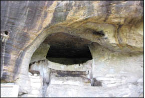
Sitabengara Cave District :Sarguja Place : Udaypur
Geo-coordinates:
Lat. 220 53’ 54” N , Long. 820 55’ 46” E
The
Sita Benrgra cave locally known as Natyasala represents a unique example of
early Indian theater. It is oblong on plan and is accessible through a flight
of rock-cut steps. The inscription on the eastern wall in a Asokan Brahmi of 3rd
century B.C. records the intimacy between an artist named Devadina (Devadatta)
and Devadasi Sutanuka. In the cave there are also two foot prints which are
scooped out of the rock.
Date of declaration of protected area/monument
and Notification No. 19.12.1964. Declared National importance vide Gazette of
India, SO No. (4271) dated 10.12.1964 under Notification No.F-4/36/64-C.1 dated
19.12.1964 declaring it to be of national importance.
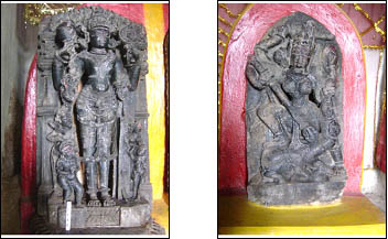
Ancient Sculptures In Danteshwari Temple District :Dantewada Place : Barsoor, Dantewada
Geo-coordinates:
Lat. 190 08’11”N, Long. 810
22'42” E
Two
images of Vishnu and one of Mahishasurmardini are kept inside a structure known
as Danteshwari temple. Stylistically the sculptures can be assigned to the
Chhindak Naga dynasty ruling over the region between 11th to 13th
century A.D.
Date of declaration of protected area/monument
and Notification No. 02.01.1954. Declared National importance vide Section-02
of the Ancient and Historical Monuments
and Archaeological Sites
and Remains (Declaration of National Importance) Amended Act 1953 (No.3
of 1954).
Bhairam Dev Temple District :Bijapur Place : Bhairamgarh
Geo-coordinates: Lat.
190 00’44” N; Long. 810 02’40” E
A
rock- cut sculpture of Ardhanarishvara is carved on a large boulder. The image
belongs to c. 13th -14th century A.D.
Date of declaration of protected area/monument
and Notification No. 02.01.1954. Declared National importance vide Section-02
of the Ancient and Historical Monuments
and Archaeological Sites
and Remains (Declaration of National Importance) Amended Act 1953 (No.3
of 1954).
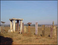
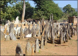
Kama Memorial Or Urasgatta Post District :Dantewada Place : Dilmili
Geo-coordinates:
Lat. 180 59’
50”N; Long .810 44’ 04”E
The site contains megalithic burials in the form of Menhirs locally known
as Urasgatta post. Among those the square memorial with wooden pillar has
carvings of different animals and human beings on its body. These are
ascribable to the late medieval period.
Date of declaration of protected area/monument
and Notification No. 02.01.1954. Declared National importance vide Section-02
of the Ancient and Historical Monuments and
Archaeological Sites and Remains (Declaration of National
Importance) Amended Act 1953 (No.3 of 1954).
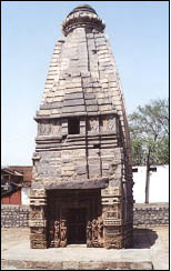
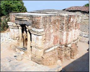
Small Vaishnava Temple District :Janjgir-Champa Place : Janjgir
Geo-coordinates:
Lat. 220 00’21” N,
Long. 82034’20” E
The temple dedicated to lord Vishnu is located to
the north-west of the large Vishnu temple. The temple consists of a garbhagriha with the remains of the antarala and a well preserved
curvilinear sikhara. Stylistically it
is datable to circa 12th century A.D.
Date of
declaration of protected area/monument and Notification No. 17.04.1913. Declared protected
monument vide GOCP, PWD, B&R Branch Notification No.60 dated
17.04.1913, confirmed vide Notification No.C-72-A-B-358 dated
11.04.1925.
Danteshwari Devi Temple, Dantewada District :Dantewada Place : Dantewada
Geo-coordinates:
Lat. & Long. 180 53’48”N,
81020’42” E
The
temple dedicated to goddesses Mahisasurmardini
is locally known as Danteshwari temple and has earned the status of Sakti Peeth. This east facing edifice
has three components viz. sanctum with a
pyramidal sikhara, a pillared audience hall and pillared dancing hall or natamandapa. Originally, built in 11th
– 12th century A.D., the temple was renovated in 14th
century A.D. by Annamadeva, brother of Prataprudra of Warangal. It has also
been extensively renovated during the early decades of the present century by
the ruling family of Bastar which regards Danteshwari as their tutelary deity.
Date of declaration of protected area/monument
and Notification No. 02.01.1954. Declared National importance vide Section-02
of the Ancient and Historical Monuments and
Archaeological Sites and Remains (Declaration of National
Importance) Amended Act 1953 (No.3 of 1954).
Megalithic Site Containing Uraskals District :Dantewada Place : Gammewada
Geo-coordinates:
Lat. 180 480
42”N; Long. 810 18’ 37” E
The
site contains megalithic burials in the form of Menhirs locally known as
Uraskals (memorial stones). These are datable to circa 3rd -4th
century A.D.
Date of declaration of protected area/monument
and Notification No. 02.01.1954. Declared National importance vide Section-02
of the Ancient and Historical Monuments and
Archaeological Sites and Remains (Declaration of National
Importance) Amended Act 1953 (No.3 of 1954).
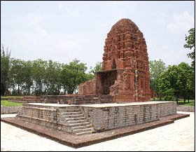
Brick Mounds, Garh Dhanora District :Bastar Place : Keshkal
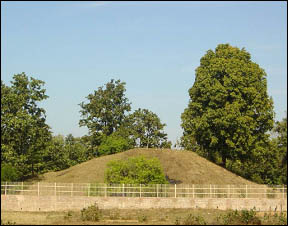
Geo-coordinates: Lat. 200 04’ 19 "N; Long. 810 33’ 18 "E
The mound at Garh Dhanora also known as Gobrain contains a number of mounds of which two are of considerable size. The bigger mound contains remnants of a brick temple dedicated to Shiv. The temple is datable to circa 12th -13th A.D.
Date of declaration of protected area/monument and Notification No. 02.01.1954. Declared National importance vide Section-02 of the Ancient and Historical Monuments and Archaeological Sites and Remains (Declaration of National Importance) Amended Act 1953 (No.3 of 1954).
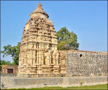
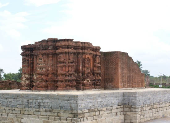
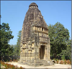
Narayan Temple, Narayanpal District :Bastar Place : Jagdalpur
Geo-coordinates: Lat. 190 11’ 59” N, Long. 81044’ 25” E
This east facing nirandhara temple dedicated to Lord Vishnu stands on a large platform. It has an imposing curvilinear sikhara. The temple is saptaratha on plan and datable to circa 12th-13th century A.D.
Date of declaration of protected area/monument and Notification No. 02.01.1954. Declared National importance vide Section-02 of the Ancient and Historical Monuments and Archaeological Sites and Remains (Declaration of National Importance) Amended Act 1953 (No.3 of 1954).
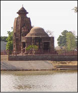
Sita Devi Temple, Deorbija District :Durg Place : Bemetara
Geo-coordinates:
Lat. 210 40’11” N,
Long. 81024’ 29” E
The
east facing edifice built of sand stone in front of a water body is surviving
with a Garbhagrih having its
curvilinear sikhara. The temple is saptaratha on plan.
The
garbhagriha is approached through a
highly ornate entrance flanked by Ganga and Yamuna on the left and right side
respectively. Depiction of Ganesa at the lalatabimba
and Navagraha on the door lintel makes the entrance more decorative. The pada
portion of the temple has five different bands depicting Lata , Pushpa , Gaja
and Nara panel separately .
The jangha portion separated from the
pada by the vandhana mouldings, has two segments adorned with images of
Ganesa, Andhakasurvadha, Shiv, Surya, Vishnu, Hari-Hara Hiranyagarbha, Laxmi,
Mahishasurmardini, Sarasvati, etc. The temple constructed by the Kalachuris can
be dated to 12th century AD.
Date of declaration of protected area/monument
and Notification No. 17.12.1920. Declared protected monument vide GOCP,
PWD, B&R Branch,
Nagpur Notification No.543Y dated
17.12.1920, confirmed vide Notification
No.1219-D.A.B dated 26.10.1922.
Shiv Temple, Gandai District :Rajnandgaon. Place : Khairagarh
Geo-coordinates:
Lat. 210 39’ 56” N,
Long. 810 06’ 14” E.
This
east facing edifice built of sand stone is popularly known as ‘Deor’ which is dedicated to lord Shiv.
The temple is surviving with a garbhagriha
having its tall curvilinear sikhara. The
square sanctum houses a Shivlinga . Seated Nandi is placed on the eastern side
of the temple. The temple is saptaratha on plan.
The
highly ornate door entrance is guarded by Saiva dwarapalas accompanied by
attendants. Depiction of Ganesha at the lalatabimba
and five Pandava brothers along with Draupadi on the door lintel makes the
entrance more unique. The pada
portion of the temple has six different bands depicting Lata , Pushpa , Gaja , Asva and Nara panel separately. The jangha has two segments adorned with
images of eight armed Shiv, Mahishasurmardini, Bhairava, Ganesha, Kaliyamardana
Krishna, Venu Gopala, and scenes from Ramayana etc. The temple constructed by the Kalachuris can
be dated to 11th century AD.
Date of declaration of protected area/monument
and Notification No. 05.07.1909. Declared protected monument vide GOCP,
PWD, B&R Branch,
Nagpur Notification No.56 dated 05.07.1909 which is addendum to
Notification No.110 dated 17.11.1906 and confirmed vide
Notification No.C-72-A-B-358 dated 11.04.1925.
Mahadev Temple Including The Math Of Bairagi And Mandapa District :Raipur Place : Narayanpur, Kashdol
Geo-coordinates:
Lat. 210 34’34” N.
Long. 820 22 ’
14”E.
This
west facing temple dedicated to lord Shiv consists of a garbhagriha and a pillared mandapa.
The temple is embellished with the sculptures of gods and goddesses as well as
secular themes including erotic figures. Stylistically it is datable to 13th-14th
century AD.
Date of declaration of protected area/monument
and Notification No. 17.06.1914. Declared protected monument vide GOCP,
PWD. B&R Branch,
Nagpur Notification No. 67
dated 17.06.1914 confirmed vide
Notification No. C-72-A-B-358 dated 11.04.1925 read with Memo No. 1096 C/AB
dated 21.11.1934.
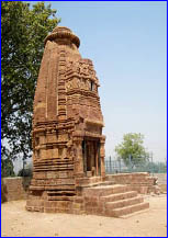
Temple Belonging To Mahantlal Das Of Sheorinarayan Dedicated To Surya, Narayanpur District :Raipur Place : Kashdol
Geo-coordinates:
Lat. 210 34’34” N, Long. 820 22 ’ 14”E.
The temple with a curvilinear sikhara standing on a platform is dedicated to Aditya or Surya. It is devoid of ornamentation
and ascribable to C. 9th century AD.
Date of declaration of protected area/monument
and Notification No. 17.06.1914. Declared protected monument vide GOCP,
PWD, B&R Branch,
Nagpur Notification No. 67
dated 17.06.1914, confirmed vide
Notification No.C-72-A-B-358 dated 11.04.1925.
Group Of Temples District :Raipur. Place : Rajim
Geo-coordinates: Lat. 20057’50” N , Long.; 81052’38”
There are two stone inscriptions, one of Vilasatunga of Nala dynasty and the other of Kalachuri feudatory ruler Jagapaladeva dated to 1145 AD. fixed on the mandapa wall of the Rajiv Lochana temple. The Kalachuri inscription refers to the construction of a Rama temple at Rajim and donation of village Salmaliya by the feudal ruler Jagapaladeva for the temple. According to the Nala inscription king Vilasatunga had constructed a magnificent and splendid temple at Rajim in the honour of his deceased son, so that his immortal deeds can be remembered. The inscription is Paleographically assigned to C. 700-725 AD. The west facing brick built edifice dedicated to lord Vishnu known as ‘Rajiv Lochana ’ is placed at the centre of a large panchayatana temple complex on a high platform approachable through flight of steps one from north and other one from south side . The temple consists of a garbhagriha , antarala and an ornate pillared mandapa. The garbhagriha houses the image of four armed Vishnu ‘Rajiv Lochana’. The tri-sakha door entrance of the garbhagriha is exquisitely carved and Seshasayi Vishnu is represented on the lalatabimba. The sikhara is pyramidal character and divided into four bhumis. The pillared mandapa is a unique architectural manifestation of its time where life size images of Narasimha, Varaha, Ganga, Yamuna, Durga, Vaishnavi, Rama and Laxmana are carved on pillar faces.
Other important temples within the precinct are Rajeswar temple, Daneswar temple, Jagannatha temple, temple dedicated to Rajim Telin Bhakti Mata. the Varaha temple, Narasimha temple, Badrinatha temple and Vamana temple are located at the four corner of the courtyard .19.07.1915. Declared protected monument Date of declaration of protected area/monument and Notification No. vide GOCP, PWD, B&R Branch, Nagpur Notification No.71 dated 19.07.1915 confirmed vide Notification No.C-72-A-B-358 dated 11.04.1925
Ramachandra Temple District :Raipur. Place : Rajim
Geo-coordinates: Lat. 20057’48”N , Long 81052’43” E
The temple dedicated to lord Rama consists of a garbhagriha and a pillared mandapa. The curvilinear super structure made of brick with lime plaster.Monolithic pillars and pilasters of the temple particularly of the pillared mandapa are all brought from the ruins of Sirpur which contains life size figures of river goddess Ganga and Yamuna and sculptures of animals such as monkey etc. A Kalachuri inscription of Jagapaladeva dated to 1145
AD. fixed on the mandapa wall of Rajiv Lochan temple refers to the construction of a Rama temple at Rajim and donation of village Salmaliya for the temple.
Date of declaration of protected area/monument and Notification No. 19.07.1915. Declared protected monument vide GOCP, PWD, B&R Branch, Nagpur Notification No.71 dated 19.07.1915 confirmed vide Notification No.C-72-A-B-358 dated 11.04.1925
Sita Bari District :Raipur Place : Rajim
Geo-coordinates:
Lat. 20057’49” N, Long.; 81052’36” E
The
site known as Sita Baree is located close to the Rajiv Lochan temple complex.
During the recent excavation work structural remains consisting of dressed
stone and bricks have been exposed which may be dated on the basis of stylistic
ground and its associated materials to 4th-5th century AD to 10th-11th cent.
AD.Date of declaration of protected area/monument
and Notification No. 18.08.1938. Declared protected monument vide GOI
Department of Education, Health and Lands Archaeology Notification No. F.4-10/38-
F dated 18.08.1938. Locally known as “Sita Baree”.
Lakshmana Temple District :Mahasamund Place : Sirpur
Geo-coordinates:
Lat. 210 21’ 12”
N, Long. 82011’13” E
An
inscription retrieved from the temple premise records that the edifice was
built by queen Vasata, daughter of Maukhari king Surya Verma of Magadha and the
widowed mother of the Panduvamsi king Mahashiv Gupta Balarjuna (A.D. 595-655).
The temple is datable to circa 625-650 A.D.
The
brick temple dedicated to lord Vishnu stands on a prominent platform and
consists of a garbhagriha, antarala
and remnants of an enclosed pillared mandapa.
The garbhagriha is approached through
an ornate stone doorway adorned with a reclining image of Seshasayi Vishnu on
the lalatabimba . Both the jambs are
embellished with panchasakha motifs such as the patrasakha, ratnasakha, mithunasakha, again patrasakha and another one
bearing depiction of various incarnations of Vishnu like Matsya, Varaha,
Nrisimha, Vamana, Rama etc. besides the mythological narration pertains to
Krishnalila, Keshivdh, Kansavadh, Hayagriva etc .
The
temple is pancharatha on plan and
roofed by a nagara sikhara (curvilinear) decorated with
imposing chaitya arches in the central ratha
and prominent amlakas in the corner rathas. The mandapa is enclosed by two side walls and has remnants of two rows
of pillars, eight on each row with corresponding pilaster on the side wall.
Date of declaration of protected area/monument
and Notification No. 17.11.1906. Declared that no objects will be moved and no
excavation will be carried out
without written permission
of the Collector and
a license from
the local Government respectively
vide GOCP, PWD, B&R Branch, Nagpur Notification No.111 & 112 both dated
17.11.1906.
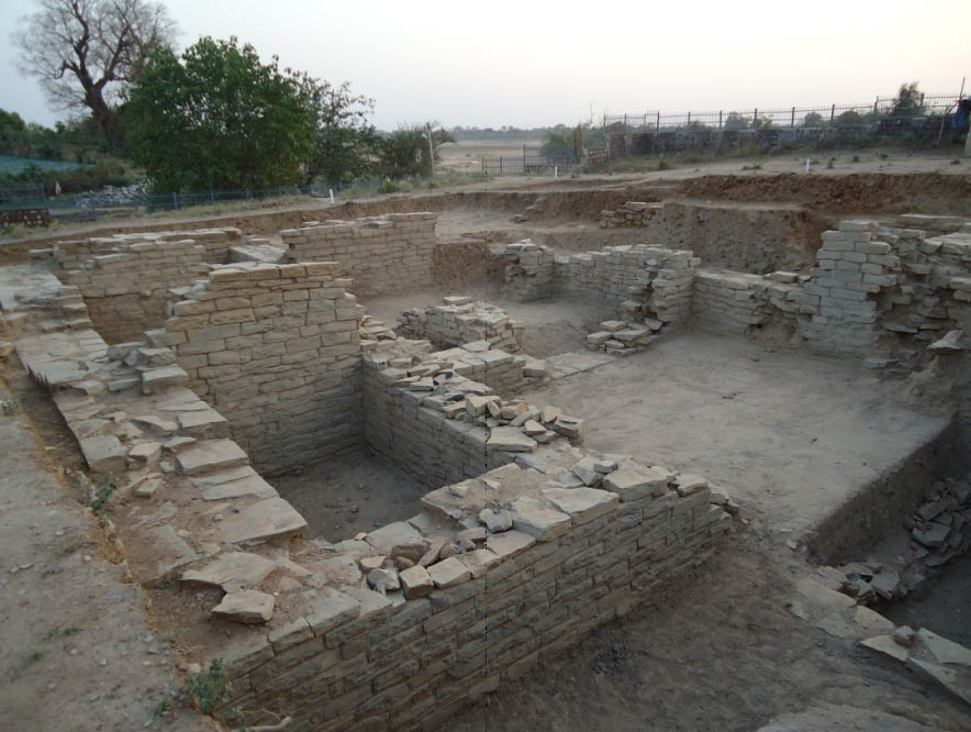
The Area Around The Sirpur Village District :Mahasamund Place : Sirpur
Geo-coordinates: Lat. 210 21’ 12”
N, Long. 82011’13” E
Apart
from Laxman temple, the ancient village Sirpur, located on the right bank of
Mahanadi in district Mahasamund is also studded with numerous ruins and remains
of archaeological importance. The volume and intensity of ruins scattered over
an area of more than 10 square km speaks the architectural grandeur of the
ancient site. Among those the structures listed below are worth mentioning.
Rama
temple, Shiv temple No. 1, SRP-22, Harsha Gupta Vihara, Tivara Dev Vihara,
Sasai Vihara, Shiv temple No. 3,
Baleshwar Mahadev temple, SRP-21, SRP-17, Padmapani Vihara, Shiv temple No. 4,
Shiv temple No. 2, SRP-16, Shiv temple No. 6, Shiv temple No. 13, Excavated
Site near the School, Palace Complex, Surang Tila.
Date of declaration of protected area/monument
and Notification No. 17.11.1906. Declared that no objects will be moved and no
excavation will be carried out
without written permission
of the Collector and
a license from
the local Government respectively
vide GOCP, PWD, B&R Branch, Nagpur Notification No.111 & 112 both dated
17.11.1906.
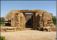
Small Brick Temple (Andaldeo Temple) , Kharod District :Janjgir-Champa Place : Pamgarh
Geo-coordinates: Lat. 210 44’48”N , Long.
82034’46” E
This
small temple built of brick was originally consisted of a sanctum and a porch.
At present, the porch is missing. The sanctum is panch-ratha on plan with acute angled pratirathas and roofed by a curvilinear sikhara. The door-jambs are embellished with large sized sensuously
carved figures of Ganga and Yamuna on either sides at the base where as Shiv – Parvati flanked by Brahma and Vishnu
on the lintel. The temple exterior is profusely decorated with stucco figures
of numerous Hindu deities assigned to
circa 7th century A.D. on the basis of style and architecture.
Date
of declaration of protected area/monument and Notification No. 10.07.1916. Declared protected monument vide GOCP,
PWD, B&R Branch,
Nagpur Notification No. 180
dated 10.07.1916 confirmed vide
Notification No.G.B-932 dated 27.08.1917 and Notification No.C-72-A-B-358 dated
11.04.1925
Mahadev Temple, Tuman District :Korba Place : Katghora
Geo-coordinates: Lat. 220 34’ 30”N ,
Long 82025’21” E
This
west facing temple built of sand stone consists with a garbhagriha and a mandapa,
both in dilapidated state of preservation. The square sanctum houses a
shivlinga and is approached through an ornate entrance adorned with images of
Ganga and Yamuna accompanied by Saiva dwarapalas. Images of Brahma, Vishnu,
Navagraha and Shiv on the lalatabimba
and various incarnations of Vishnu on the door jambs are making the entrance
more ornate. The jangha portion separated from the pada by the vandhana
mouldings has two segments embellished with geometrical and floral motifs,
diamond designs, trampling lion, Bhara
vahakas, marching elephants etc. The
temple is saptaratha on plan.
Tuman Inscription of late Kalachuri period reveals
that around 900 AD Tuman was built as the first capital of the Kalachuris of
South Kosala . According to the Ratanpur inscription of Jajalladeva-I dated to
Kalachuri samvat 866 ‘king Ratandeva-I
had constructed many temples at Tuman’.
Based
on the inscriptional reference scientific investigation was carried out at
Tuman during 2008-09 and 09-10 which has unearthed remains of 20 temples and
many sculptures of Vaishnava, Saiva and Sakta faith. Among the images Brahma,
Vishnu, Gajantakshiv, Surya, Ganesha, Vasu, Hanuman, Narasimha, Gajalaxmi,
Chamunda and erotic figures etc are worth mentioning.
Date of declaration of protected area/monument
and Notification No. 28.07.1916. Declared protected monument vide GOCP,
PWD, B&R Branch, Nagpur Notification No.280 dated 28.07.1916
confirmed vide Notification No.GB-935 dated 27.08.1917 and Notification
No.C-72-A-B-358 dated 11.04.1925 with declaration of non- movement of any
object within the permission of the Deputy Commissioner vide Notification No.281
dated 28.07.1916.
Chandraditya Temple District :Dantewada Place : Barsoor
Geo-coordinates:
Lat. 190 08’14” N, Long. 81022’58”
E
The
temple built on a high platform dedicated to lord Shiv is believed to have been
built by a feudatory chief (Mahamandalesvara) Chandraditya hence called Chandraditya temple. The temple is pancharatha on plan and consists of a garbhagriha and a pillared mandapa
datable to 11th century A.D.
Date Of Declaration Of Protected Area/Monument
And Notification No. 02.01.1954. Declared National importance vide Section-02
of the Ancient and Historical Monuments
and Archaeological Sites
and Remains (Declaration of National Importance) Amended Act 1953 (No.3
of 1954).
Karli Mahadev Temple District :Dantewada Place : Samlur
Geo-coordinates:
Lat. 180 58’ 36”
N; Long. 81018’ 13” E
The
east facing Karli Mahadeva temple externally plain in character consists of a
sanctum with a heavy curvilinear sikhara
and an antarala with a pyramidal
super structure. The temple is pancharatha
on plan and ascribable to 12th
13th century A.D.
Date of declaration of protected area/monument
and Notification No. 02.01.1954. Declared National importance vide Section-02
of the Ancient and Historical Monuments and
Archaeological Sites and Remains (Declaration of National
Importance) Amended Act 1953 (No.3 of 1954).
Mud Fort, Kotagarh District :Janjgir-Champa Place : Bargaon, Akaltara,
Geo-coordinates: Lat. 220 03’
01”N, Long. 820 26’ 04”E
Brief
Description: The fort approachable by two gateways is square on plan with
remnants of 16m high rampart in the east. The western gateway with its arch is
well preserved. An inscription on the gateway assigns the date to 10th century
A.D.
Date of declaration of protected area/monument
and Notification No. 17.12.1920. Declared protected monument vide GOCP,
PWD, B&R Branch,
Nagpur Notification No. 543Y dated 17.12.1920, which was confirmed vide
Notification No.1219-D.A.B dated 26.10.1922.
Mud Fort, Malhar District :Bilaspur Place : Masturi
Geo-coordinates: Lat. 210 53’ 51”N,
Long. 82016’ 37”E
The
ancient mud fort is surrounded by a large moat and has risen to a height of
about 15 mt. from the ground level. It was under occupation between 2nd
century B.C. to 12th century A.D.
Date of declaration of protected area/monument
and Notification No. 17.12.1920. Declared protected monument vide GOCP,
PWD, B&R Branch,
Nagpur Notification No. 543Y dated 17.12.1920, which was confirmed vide
Notification No.1219-D.A.B dated 26.10.1922.
Pataleshwar Mahadev Temple District :Bilaspur Place : Malhar, Masturi
Geo-coordinates:
Lat. 210 53’ 43”N, Long. 82016’ 47”E
An
inscription dated A.D. 1167-68 records that the main temple of Patalesvara
Mahadeva, dedicated to Kedara (Shiv) in Mallala (modern Malhar), was built by a
Brahman, native of Kumhati during the
reign of Jajalladev of the Haihaya dynasty. The temple is built on a high
platform and consists of a square sanctum and a mandapa. The garbhagriha
housing a shivlinga is placed at a lower level than the mandapa.
Date
of declaration of protected area/monument and Notification No. 22.07.1937.
Declared protected monument vide GOI, Department of Education, Health and Lands, Notification
No.F.11-8/37-F dated 22.07.1937 confirmed vide No.F.11-8/37-F dated
07.10.1937.
Mahadev Temple District :Korba Place : Pali
Geo-coordinates:
Lat. 22022’23”N,
Long. 82019’24” E
This
east facing edifice built of sand stone on a high platform is surviving with
the Garbhagriha with Nagara sikhara
and an octagonal mandapa. The
square sanctum houses a shivlinga. The exquisitely carved door entrance to garbhagriha is adorned with images of
Ganga and Yamuna accompanied by Saiva dwarapalas. Depiction of Brahma, Vishnu
along with Navagrahas and Shiv on the lalatabimba
makes the door lintel more decorative. The temple is saptaratha on plan. The mandapa
is embelished with images of Brahma, Krishna, Saraswati, Mahishasurmardini, Gaja Laxmi etc.
The
jangha portion separated from the pada by the vandhana mouldings, is adorned with images like eight armed dancing
Shiv, Chamunda, Surya, Tripurantak Shiv and Kartikeya, the scene like monkey
pulling the wet cloth of a lady, lady applying vermilion on her forehead or
looking at mirror etc.
An
inscription engraved on the door frame of the garbhagriha states that the temple was constructed under the
patronage of Vikramaditya (870 AD to 900 AD) of the Bana dynasty.
Date of declaration of protected area/monument
and Notification No. 28.09.1908. Declared protected monument vide GOCP,
PWD, B&R Branch,
Nagpur Notification No.61 dated 28.09.1908 which is an addendum to
Notification No.110 dated 17.11.1906, confirmed vide Notification No.C-72-A-B-358
dated 11.04.1925.
Fort, Ratanpur District :Bilaspur Place : Kota
Geo-coordinates:
Lat. 220 17’
03”N, Long. 820 10’02” E
The
ancient fort at Ratanpur was probably constructed by the Kalachuri king
Ratnadev-I who founded Ratanpur during his rule between 1045 to 1065 AD and
shifted the capital from Tuman. Numerous structural remains of later period are
found within the fort limit among which the palace complex and Hamam are
noteworthy. On the fort wall some
sculptures are found which were of course fixed at a later date. Among these
one depicting Ravana sirsharpana
scene is the most interesting.
Date of declaration of protected area/monument
and Notification No. 17.09.1906. Declared that no objects will be moved and no
excavation will be carried out
without written permission
of the Collector and
a license from
the local Government respectively
vide GOCP, PWD, B&R Branch, Nagpur Notification No.111 & 112 both dated
17.09.1906
Keshava Narayan Temple, Sheorinarayan District :Janjgir-Champa Place : Pamgarh
Geo-coordinates: Lat. 210 43’ 10” N, Long. 820 35’22”
The brick temple of Keshava Narayana dedicated to Vishnu consists of a sanctum, antarala and a newly constructed mandapa. Sanctum is circular on plan. The temple belongs to circa 9th century A.D. Scientific clearance was carried out in the south side of the temple adjacent to its wall has revealed the original activity level below 1.5 m. The investigation has brought to light the original moulded, intricately carved jagati part of the edifice. The temple was Pancharatha on plan and was built in Bhumija style.
Date of declaration of protected area/monument and Notification No.17.12.1920. Declared protected monument vide GOCP, PWD, B&R Branch, Nagpur Notification No.543-Y dated 17.12.1920 confirmed vide Notification No. 1219-D.A.B dated 26.10.1922.
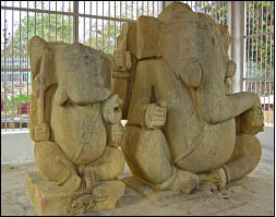
Ganesh Statues District :Dantewada Place : Barsoor
Geo-coordinates:
Lat. 190 08’03” N, Long. 810 22’25” E
Two
monolithic sitting Ganesa statues measuring about 2.13m and 1.67m in height
belonging to the 11th -12th century A.D have been carved
in granite stone and represent high skill of craftmanship.
Date of declaration of protected area/monument
and Notification No. 02.01.1954. Declared National importance vide Section-02
of the Ancient and Historical Monuments
and Archaeological Sites
and Remains (Declaration of National Importance) Amended Act 1953 (No.3
of 1954).
Mama Bhanja Temple District :Dantewada Place : Barsoor
Geo-coordinates: Lat. 190 08’15”N , Long. 810 22’26” E
The temple dedicated to Lord Shiv
is built on a moulded base. It is 16m in
height with a well preserved imposing
curvilinear sikhara over the sanctum.
An inscription in Telugu characters datable to the thirteenth century A.D is
found on the temple platform.
Date of declaration of protected area/monument
and Notification No. 02.01.1954. Declared National importance vide Section-02
of the Ancient and Historical Monuments
and Archaeological Sites
and Remains (Declaration of National Importance) Amended Act 1953 (No.3
of 1954)
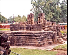
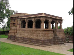
Bhand Deul District :Raipur Place : Arang
Geo-coordinates: Lat. 21011’43”N, Long. 81058’ 10”E.
The temple locally known as Bhand Deul is having a stellate garbhagriha, enshrining images of three Tirthankaras namely Ajitanatha, Neminatha and Sreyansanatha.. On plan it once consisted of a sanctum, mandapa and a porch of which the later two are lost now. The garbhagriha with its rekha sikhara is richly carved and adorned with beautiful sculptures including some erotic figures.Stylistically the temple is assignable to the early Haihaya period i.e. circa 9th century AD.
Date of declaration of protected area/monument and Notification No. 17.12.1920. Declared protected monument vide GOCP, PWD, B&R Branch, Nagpur Notification No.543Y dated 17.12.1920, confirmed vide Notification No.1219-D.A.B dated 26.10.1922.
Mahadev Temple District :Bastar Place : Bastar
Geo-coordinates:
Lat. 190 12’44”N, Long. 810
55’57” E
The
temple built over a moulded base consists of a sanctum and a mandapa. The sanctum has a pyramidal
sikhara surmounted by a small amalaka
where as the mandapa has simple flat roof.
It is datable to circa 12th century A.D.
Date of declaration of protected area/monument
and Notification No. 02.01.1954. Declared National importance vide Section-02
of the Ancient and Historical Monuments and
Archaeological Sites and Remains (Declaration of National
Importance) Amended Act 1953 (No.3 of 1954).
Mahadev Temple District :Durg Place : Deobaloda
Geo-coordinates: Lat. 210 13’08” N, Long. 81028’24” E
This east facing edifice built of sand stone is surviving with a garbhagriha and a pillared Navaranga mandapa. The sikhara is missing which was probably in Nagara style. The garbhagriha houses a Shiv linga and is approached through a highly ornate entrance guarded by Saiva dwarapalas accompanied by attendants. Ganesha is depicted on the lalatabimba. The mandapa pillars are adorned with images of Bhairava, Vishnu, Mahishasurmardini, Tripurantaka Shiv, Venu Gopala, musicians, dancers, keertimukha designs etc.
The exterior of adhisthana portion of the temple bears decorative bands of Gaja, Asva and Nara. The Bhitti portion has two decorative segments, adorned with images of Tripuarantaka Shiv, Gajantakashiv, Narasimha, Nruvaraha, Parvati, Radha-Krishna, Ganesa, Mahishasurmardini, Laxmi, Trivikrama,Venu Gopala, Kesi vadh etc. The temple constructed by the Kalachuris can be dated to 14th century AD.
Date of declaration of protected area/monument and Notification No. 28.09.1908. Declared protected monument vide GOCP, PWD B&R Branch, Nagpur Notification No.61 dated 28.09.1908 which is an addendum of Notification No.110 dated 17.11.1906 and confirmed vide Notification No.C-72-A-B-358 dated 11.04.1925.